 and learn more about the earth that way.
Friday, October 25, 2013
How can ocean floor features be measured and mapped using current acoustical technology? How can ocean floor maps be used in the commercial, military, and/or private sector?
There are various instruments in today's society that would allow for better mapping of the sea floor. Sonar is till the best way how ever, to map the sea floor. It has come a long way since it was originally created and can give more accurate information on what the terrain is like underwater. We are also at the point that we can have robots do much of the work that we as humans would be incapable of doing. They can go to further depths and for longer periods than we can. Accurate ocean floor maps benefit everybody, not just particular groups like oceanographers. For example, if the military had a better idea at what the sea floor was like around the world, the use of submarines could be used more adequately. In the private sector such as research, and other scientific business, it opens a variety of different opportunities. It allows for deep water research that previously could not have been done. For example, we could take core samples out of an unexplored area 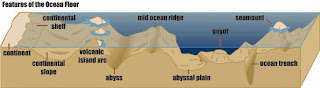 and learn more about the earth that way.
and learn more about the earth that way.
Subscribe to:
Post Comments (Atom)
No comments:
Post a Comment