
Thursday, January 16, 2014
Moon and Tides
Tides are caused by a gravitational tug-of-war between the sun,
moon, and earth. All objects exert gravitational pull on each other. The
closer they are, or the larger they are, the greater the force of the pull the object will feel. All of
the planets exert some gravitational pull on the earth. However, the
pull of the moon and sun are most noticeable because the moon is
so close to us and the sun is so big. It takes the earth 365 days to
revolve around the sun. As it revolves around the sun, it spins, or
rotates on its axis once every 24 hours. At the same time, the moon
revolves around the earth once every 29 days. The gravitational pull of
the sun holds the earth in orbit, while the gravitational pull of the
earth keeps the moon in orbit.As a result of this gravitational
attraction between the earth and the moon, the side of the earth facing
the moon is pulled towards it. Solid objects like the ground and buildings are not distorted as much as liquids like the ocean. A bulge of water occurs on the side of the earth facing the moon.
As the earth rotates around the sun, centrifugal force causes an equal
bulge of water on the opposite side of the earth. Water is pulled away
from these two sides of the earth to form these bulges, or high tides. This leaves a depression, or low spot, in the oceans between. These are the areas of low tides.
Friday, December 6, 2013
Which Way the Wind Blows
1. The uneven heating of the earths surface is caused by the tilt of the earth. The suns rays hit the surface of earth at such an angle that it unproportionately heats certain parts of the earth while other parts are not heated. If the rays were to hit the earth at a direct path as opposed to at an angle, the earth would be much hotter. The equator receives more direct rays and as a result it is hotter there than the rest of the planet. This can be shown by shining a flashlight directly on a globe at an angle as well as directly.I learned how important the tilt of the earth is because without it the earth would be much hotter and potentially uninhabitable.
2. As a result of the earth rotating, the winds and oceans are affected. Consequently, the winds and oceans also affect each other. The coriolis effect is a result of the earths rotation. It causes winds and currents north of the equator to turn the right. The winds and currents turn to the left in the southern hemisphere.Hadley cells are the pattern in which things circulate. This can be shown by spinning a flat surface around something and dropping a rollable object on it. The object will not go right to the outside of the surface, it will curve there.
3. The global wind patterns are an important part of the earth. In each hemisphere, there are polar easterlies, trade winds, doldrums, and prevailing westerlies. They are all located between different latitudes and have different effects. The polar easterlies cool down the rest of the earth with their cool winds. The doldrums are an area around the equator in which very little wind is produced.
The winds could change due to global warming as a result of the melting of the ice caps. If there is no ice to cool the air then there is no polar easterlies.


Friday, November 22, 2013
Logger Head Island
1. We wanted to keep as much of the civilization away from the hatching area as possible. To do this, we only put the research center near the turtles for easier access for researching purposes. The houses that are further away from the beach all have lighting restrictions after a certain time of day to prevent confusion to hatched turtles.
2. We put it on the opposite end of the island so that there was not to much at one end. We made it so it faces directly into the ocean for the most optimal fishing. It was also away from any of the islands natural occurrences.
3. It could take up a lot of the islands natural space. It could also potentially make a new Eco system on its own causing some of the natural species to migrate to it. Some of the ways it could be reduced would be to place the golf course in a smaller portion of the island away from the naturally occurring things.
4. It would be a very beautiful community that a lot of people would like to vacation on. The golf course alone would be a very good economic booster for the area, as well as all of the homes that would be sold.
5. We make public beaches in potential nesting areas. We leave trash that the animals could potentially eat and choke on and we also can disrupt the naturally occurring waves by building sea walls and jetties.
6.They all act as a natural cement in a way by preventing the waves from doing to much damage. They take away some of the impact and keep a lot of the natural sediment in place.
7. Our group had a lot of good ideas that other group had already integrated into their own islands.

Friday, November 15, 2013
Molasses Spill
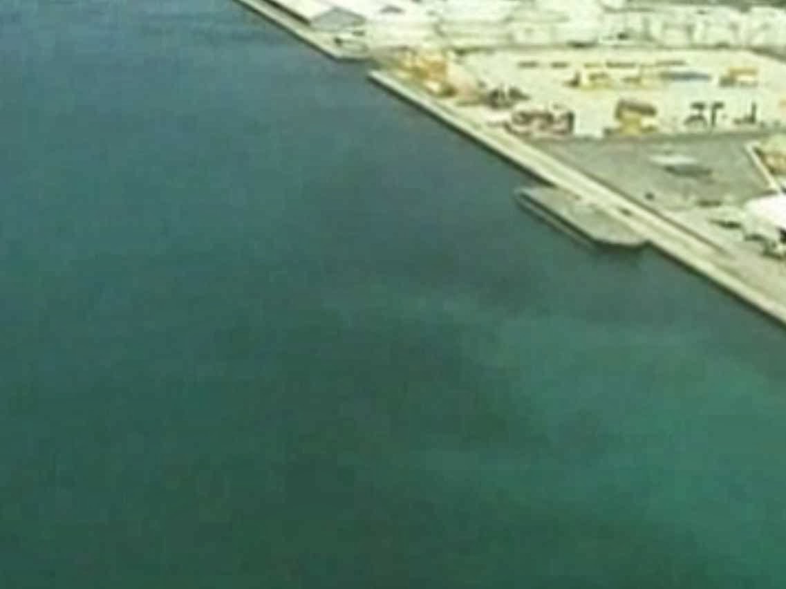
The molasses spill off of the coast of Hawaii is an environmental nightmare. Although not as dangerous as an oil spill, much the the sea life is being affected by the spill and many even dying. The video recorded by a local diver shows the true affects of the spill, turning the once blue-green water into a brown mess. The video also shows many dead fish floating around or sinking to the ocean floor. As a result of a faulty pipe pumping the molasses into the ocean instead of it's destination in California The sticky molasses takes the oxygen out of the water and blankets the ocean floor.
The molasses spill is not only harmful to the marine life in the area, but also to humans as well. Although the molasses does no affect to humans, the dead and rotting fish in the water are making it unsafe to swim in. AS far as clean up goes, much of the work will be done naturally using the tides to wash it all out. The man who recorded the underwater mess said that, "We had a large sewage spill six or eight years ago. It was a stinky mess, but nothing like this."

The molasses spill is not only harmful to the marine life in the area, but also to humans as well. Although the molasses does no affect to humans, the dead and rotting fish in the water are making it unsafe to swim in. AS far as clean up goes, much of the work will be done naturally using the tides to wash it all out. The man who recorded the underwater mess said that, "We had a large sewage spill six or eight years ago. It was a stinky mess, but nothing like this."
Experimental Design
I was not able to go on the recent Oceanography field trip so I wrote about the experimental deign of a research trip to the South Pacific. I was familiar with some of the materials that the trip would require due to our most recent in class project with the underwater habitat. The trip would be a minimum of two weeks because just arriving to the destination took seven days. With that in mind, I planned the resources accordingly. There would be plenty of food, and I made sure that there were enough oxygen tanks and other necessary materials to observe the clams properly without harming them. It would be better if the clams would perform their mating ritual while on board the ship so that the scientists don't have to be underwater for the four-six hour mating process. Some of the other materials that may be necessary for the best operation are large holding tanks, and natural materials from the clams natural environment so that the snails are as comfortable as possible as to perform their mating while on the ship. If the scientists were to perform an autopsy on one of the clams, they would need surgical equipment such as a scalpel and would also need a microscope as to view the clam clearly.


Friday, November 1, 2013
Sand Reflection
The two sands that I am going to compare are from the Bahamas and, Cancun. The bahamas are known for it's white/ pink beaches. This is because it's sand composition is made up of alot of coral. There are a lot of coral reefs offshore and when they break off, they are moved toward the beach. After waves constantly crashing down on them, they are broken down small enough that it looks like sand. Under microscope, the particles looked large in comparison to other grains. The sand that I looked at undermicroscope from Cancun was very different. Though it had a similar white color of the sand, that is all it really shared. The pieces of sand were smaller in size and were rather rounded meaning that they are be bombarded by waves on a more constant basis. The sand was not quite as coral based. It had a more rocky sediment in it that i would assume came from a graite compound. The magnetite for both groupings of sand was rather strong.


Friday, October 25, 2013
How can ocean floor features be measured and mapped using current acoustical technology? How can ocean floor maps be used in the commercial, military, and/or private sector?
There are various instruments in today's society that would allow for better mapping of the sea floor. Sonar is till the best way how ever, to map the sea floor. It has come a long way since it was originally created and can give more accurate information on what the terrain is like underwater. We are also at the point that we can have robots do much of the work that we as humans would be incapable of doing. They can go to further depths and for longer periods than we can. Accurate ocean floor maps benefit everybody, not just particular groups like oceanographers. For example, if the military had a better idea at what the sea floor was like around the world, the use of submarines could be used more adequately. In the private sector such as research, and other scientific business, it opens a variety of different opportunities. It allows for deep water research that previously could not have been done. For example, we could take core samples out of an unexplored area 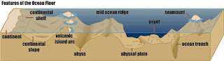 and learn more about the earth that way.
 and learn more about the earth that way.
Subscribe to:
Posts (Atom)